 +31 (0)50 367 71 97
  info@connect-int.org
Maybe you have heard or read about it in the news; the earthquakes affecting the province of Groningen. Or maybe you have felt one yourself; it can be alarming.
In 2014 I was living in Groningen city centre when a earthquake hit near the city. It measured only 2.8 on the Richter scale, and yet I could feel the house around me trembling. At the time I had not heard about the earthquakes caused by the extraction of gas in the north of the province, so when it hit I was not prepared and did not know what was happening, or if I should be running out of my flat, or taking cover under a table- similar to the panic I felt the first time I heard the air raid siren drills.
The further north-east you live in the province of Groningen, the more you will notice these earthquakes and be affected by them. And while until now no one has been killed as a result of the earthquakes, it is unsure what will happen in the future.
The gas field under Groningen was discovered in 1959 near Slochteren measuring 45 km long and 25 km wide, it is the largest natural gas field in Europe. It is the extraction of gas from the Groningen gas field that causes the numerous low magnitude earthquakes experienced in the region. The first earthquake was reported close to Assen in 1986 and the frequency of earthquakes has steadily increased, with a total of 1393 to date (01/06/2017), ranging from 0.1 to 3.6 on the Richter scale. The earthquakes around Groningen are very shallow, usually around 3km below ground, making the damage they cause to buildings greater than their small Richter-scale magnitudes might suggest.
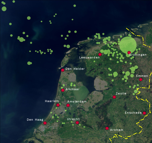
In 2014, the extraction of gas was capped to help reduce the number of earthquakes, and in 2016 it was lowered again to 24 billion cubic meters. However, the effects of extracting gas occur 9-12 months later, so it is not yet known if the cap is sufficient. Scientists have speculated that an earthquake measuring 4 or 5 on the Richter scale may occur in the future. Groningen city itself has been fortunate enough to only experience a handful of earthquakes, with the majority by fat still affecting further north in the province.
The Dutch website KNMI (Koninklijk Nederlands Meterologisch Instituut) have a map where you can see the latest earthquakes in the region and how strong they were.